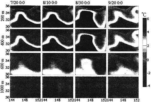
Figure 4.Ѓ@Temperature anomaly (ѓВT) distributions in the horizontal sections of 200, 400, 600, 1000m depths. The results of inversion are shown about every 20 days between July 20 and September 20. Color codes of temperature are presented at the right edge of the figure.
Ѓ@
Discussion
Ѓ@
The preliminary result from the 1000-km scale four-dimensional tomography experiment provides the large variability of the temperature fields in the Kuroshio Extension region with 6-hour time resolution. Durig the observation period, the Kuroshio Extension front takes a meander path and induces a pair of warm and cold eddies at the most developed phase (during the end of Summer 1997). From the Geosat altimetry data Qiu [1991] found that the annual variations of the surface height diference dh across the Kurosio Extension in region of 141Ў? and 154Ў? had a September maximum and anonmalies of the dh were significantly correlated with the current axis positions. No discussion of any seasonality of the Kuroshio Extension can be made here because of the limited duration of the experiment. The meridional path transition of the Kuroshio Extension affects the variability of storm tracks, and may be important for the climate change study in the northwest Pacific [Mitsudera, 1998, personal communication].
The shipboard ADCP observations, conducted during the recovery cruise from September 20 through October 2, provides a good comparison with the tomography observation. Velocity vectors at 190m depth are compared with the 20th September tomography result at 200m depth Fignre 5. The stream axis of the Kurosio Extension traced with the biggest vectors (the maximum velocity is 1.2m/s) are in rough agreement with the position of the 14-16ЃKC isotherms, indicating the Kuroshio Extension front. The position of the Kuroshio Extension determined by the shipboard ADCP observation makes little change with depth (not shown here).