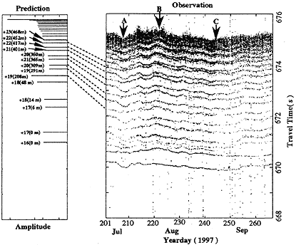
Figure 2.Ѓ@The time series of the travel times with positive anival angle (+10Ѓ‹) for transmissions from mooring T5 to T2 (1000.4km range, along the T/P track p238, seeing Figure 1). The largest 50 peaks are plotted; transmissioas occured every 3 hours in August and every 6 hours in July and September. The predicted arrival pattern derived from an area-averaged reference constructed from NODC hydrographic data is shown at the left of the figure; the dashed lines indicate the rays that were used in the inversion.
Ѓ@
Inversion
Ѓ@
Ten horizontal paths are obtained between the 5 transceivers moorings (reflecting the quadratic increase in number of tomographic paths with the linear increase in the number of instruments). Each station pair has about 14 identified ray paths with upper turning points in the depth range 100-500m (Figure 2). Data from the clustered arrivals (corresponding to ray near the sound channel axis) are not used in the inversion because of large uncertainty in travel times. A total of 141 ray paths are used for the inversion. The preliminary inversion for sound speed (temperature) discussed here used only the average of the travel times in reciprocal directions along individual ray paths to remove the uncertainty caused by oceanic currents. A 2-day running mean is applied to the time series data of travel times to remove higher-fequency fluctuations such as tides, inertial oscillations and internal waves.
The linear stochastic inversion [Aki and Richards, 1980; Munk et al., 1995] is used to rconstruct the sound speed anomaly fields from the travel time data. An area and time averaged reference sound speed profile was determined from historical hydrographic data; the latter were collected in the experiment region from 1968 to 1986 during June to August [NODC, 1991].