Thus, the freshening trend in the upper pycnocline was apparently a relaxation towards climatologaical values of salinity. The recent trend reversal occurred before 乬normal乭 conditions had returned, and the upper pycnocline is again becoming anomalously salty.
丂
LARGE-SCALE CONTEXT
丂
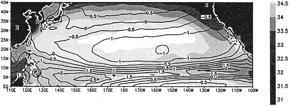
The annual mean sea surface salinity (SSS) from Levitus et al. (1994) is shown in Fig. 6, along with the annual mean net freshwater flux for the North Pacific Ocean. The net freshwater flux is estimated from the CMAP rainfall dataset, and the evaporation is from the NCEP/NCAR reanalysis. An elongated region of SSS亜35 pus exisits along 25亱N, from about 150亱E to 135亱W. This salinity maximum lise under a zonal band where there is a net loss is about 5亱south of the salinity atmosphere on average, but the maximum freshwater loss is about 5亱 south of the salinity maximum. This is due to the northward component of surface flow driven by the easterly Trade Winds, and the fact that the loss of freshwater is accumulated along the trajectory of the water parcel. The reversal of the meridional gradient of SSS under the region of net loss from the ocean is due to southward flow of fresher waters under the influence of the midlatitude westerlies. Thus, theSSS maximum is in a region of convergence associated with the existence of the Subtropical Front (cf. Nakamura et al., 1997). At this front, waters are subducted, forming the shallow salinity maximum of the eastern North Pacific Ocean (Tsuchiya, 1968; O'Connor et al., 1998), which is observed at Station ALOHA (Fig. 2). Obviously, rainfall and evaporation are subject to interannual and longer variations, and these may cause salinity changes near the Subtropical Front which could be manifest with some delay (cf. Bingham, 1998) at Station ALOHA.
丂
Figure 6.丂Annual mean sea surface salinity (gray scale) from Levitus et al. (1994), and annual mean net freshwater flux (contours in m). Regions of net loss from the ocean are indicated by dashed contours.
丂
Midlatitude storms track north of the Hawaiian Islands during winter, and they are responsible for much of the rainfall over the North Pacific Ocean (Fig. 7). Interannual variations of the storm tracks and intensity result in notable changes in precipitation even over fairly large areas. There is not much variation in summertime rainfall over the eastern North Pacific, but there are pronounced differences in the winter season peak rainfall rate and its timing (Fig. 8). During the first half of the 1980s, winter rainfall is relatively high, and relatively low during 1990-94. From 1995 onward, winter rainfall in the ENP is relatively greater again, with two of the years the highest in the record. The monthly anomalies (departures from 1979-1997 climatology) show that events of a month or two dominate, which is consistent with storm track variability. There is however an underlying decadal variation, with a peak in the mid-80s, a minimum in 1990, and another peak in 1996.