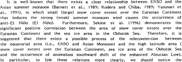
Here, we should notice the existence of the decadal changes in global oceanic and atmospheric circulation. The teleconnection between the SST change in an equatorial Pacific and the southward development of the Aleutian Low (PNA pattern) are dominant before 1988, while the influence of the equatorial SST on the height of 500 hPa is relatively weak after 1989 (Perlwitz and Graf, 1995; Kodera et al., 1996; Nakamura et al., 1996; Koide and Kodera, 1997). Furthermore, the anthropogenically induced trend is suggested by Thompson and Wallace (1998), which imply the influence of linear trend on the decadal change. Since the last decadal characteristic change after 1989 has not accomplished yet, we focus on these observational data before 1988. Therefore, the relationships among the sea ice area in Okhotsk Sea, snow cover extent over the Eurasian Continent and the occurrence of the southernmost shift of the Oyashio and subarctic circulation of the North Pacific are examined in this study.
DATA
Monthly mean southernmost latitude of the subarctic circulation supplied by Japan Meteorological Agency is estimated as the southernmost latitude of the Oyashio (Fig. 1a) defined by southernmost latitude of the 5℃ isothermal at the depth of 100m in the first Oyashio intrusion (cf., Kawai, 1972), which is a southward development area of the Oyashio water nearest to Japanese coast. It should be noticed that because this latitude is defined by temperature fields, the lag of three-four months from the actual southernmost latitude defined by valocity fields which is caused by the barcotopic response of the ocean to the change in wind stress (Sekine, 1999).
Sea ice area in the Okhotsk Sea (Fig. 1b), which is defined as the area with the ice concentration more than 10%, is supplied from Japan Meteorological Agency. Snow cover extents over the Eurasian Continent (Fig. 1c) are supplied from Climate Prediction Center of NOAA by down loading from the internet information file named northern hemisphere snow cover area. Satellite data over 89×89 grids are used to estimate the snow cover extents and its accuracy is an order of 105 km2.