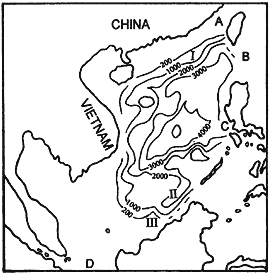
Fig.1丂Bathymetric map of the South China Sea A: Taiwan Strait;丂B: Luzon Strait;丂C: Mindoro Strait;丂D: Karimata Strait;丂I: Dongsha Islands;丂II: Nansha Trough;丂III: Beikang Shoals
Fig.1丂Bathymetric map of the South China Sea
A: Taiwan Strait;丂B: Luzon Strait;丂C: Mindoro Strait;丂D: Karimata Strait;丂I: Dongsha Islands;丂II: Nansha Trough;丂III: Beikang Shoals
丂
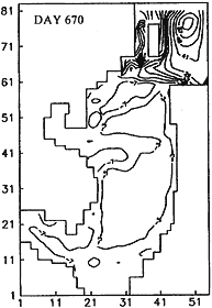
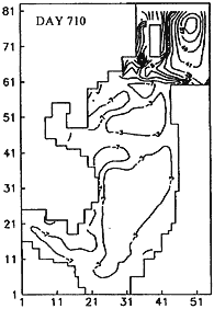
Fig.6丂SSH distribution for days 670 and 710 of integration time from a two-layer model under Hellerman-Rosenstein August climatology winds
BACK丂丂丂CONTENTS丂丂丂NEXT