These findings also suggest the mixing process occurs along the length of the Kuroshio extension [Yasuda et al., 1996], whereas earlier studies [Talley, 1993] indicated that the formation site of NPIW is located near the south-western edge of the subarctic gyre, where the Kuroshio and Oyashio Currents collide for the first time. A recent analysis of drogued drifters suggest that, in spite of a rather variable position of the inter-gyre frent, very little cross-frontal exchange occurs near the sea suface [Meximenko et al., 1998].
Recently, this research has been supplemented through Lagrangian drifters at mid-depth. Within WOCE, Riser [Riser, 1995] focused on the large scale flow pattern of the western North Pacific [Riser, 1998]. A total of 66 floats were launched into the intermediate layer at nominally 1000m. There results are matched by overall displacements vectors from 18 RAFOS floats deployed by Dr. Shikuma at similar and shallower levels. The floats reveal a mainly zonal and predominantly eastward flow over a wide meridional range 20Ў? to 40Ў?. However, this data is of relatively low density, and with regard to a direct description of the Kuroshio Extension proper definitely too spare to answer key questions regarding inter-gyre exchanges which also remain obscured, even in multi-ship hydrographic surveys due to their transient nature.
Ѓ@
THE TRIANGLE AND TOLEX PROJECTS
Ѓ@
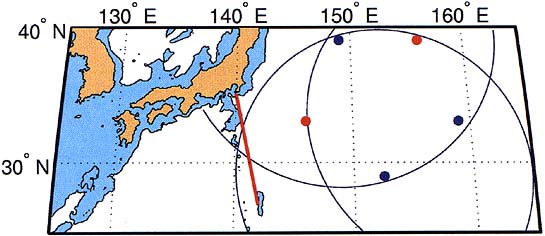
To overcome these shortcomings in the understanding of the subsurface component of the Kuroshio Extension, but also to study the overall role of the Northern Pacific in the global climate, a number of projects have been proposed within the Triangle. The central element (Region C) of Triangle is a pentagonic mooring array of tomographic sound sources. The proposed array [Mitsudera, 1998] also encompasses 2 TRITON buoys and a significant number of Inverted Echo Sounders, 8 current meter and CTD moorings and ship-born CTD surveys. Most of these components will be deployed between 2001 and 2003 in the area encompassing the Kuroshio Extension (Figure 2).