It is concluded that the clear relation-ship between the Kuroshio path and and sea level difference between Kushimoto and Uragami is caused by the different approaching of the warm Kuroshio water to Japanese coast between in nLMP periods and in LMP periods.
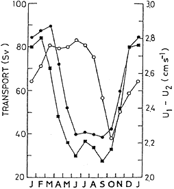
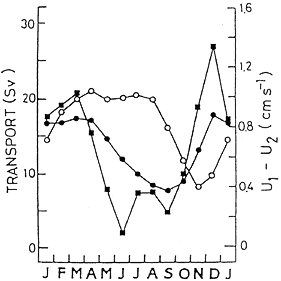
Thirdly, the observational evidence that the observed geostrophic volume transport of the Kuroshio takes maximum in summer and minimum in winter, however, Sverdrup transport estimated by the observed wind stress takes maximum in winter and minimum in summer (Fig. 4). The discrepancy between the observed geostrophic volume transport and the Sverdrup transport is examined by use of two layer numerical model driven by the observed wind stress compiled by Kutsuwada and Teramoto (1987). Here, two numerical models shown in Fig. 5 are examined (Sekine and Kutsuwada, 1984). It is shown from a flat bottom model (Fig. 5b) that the western boundary current has a maximum transport (90 Sv) in late winter and a minimum transport (40 Sv) from summer to early autumn (Fig. 6a). The time lag of the calculated transport from Sverdrup transport is about one month, which shows that the barotropic response is dominant for the seasonal change in the wind stress. However, the vertical velocity difference at the western boundary region becomes maximum in summer and minimum in autumn (Fig. 6a), of which summer maximum and autumn minimum coincide with the observed geostrophic transport shown in Fig. 4a. It is shown from a simplified bottom model (Fig. 5c) that the western boundary current has a maximum volume transport (18 Sv) in winter and minimum (7 Sv) in