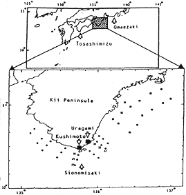
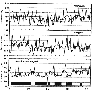
Fig. 2丂(a)Locations of Kushimoto and Uraigmi in the southern tip of Kii Peninsula (Siono-misaki). Observatlonal stations of Wakayama Prefectual Fisheries Experimental Station (circles) and of Fisheries Research of Mie (squares) are also shown. (b)Sea level changes at Kushimoto (upper) and at Uragami (middle) and sea level difference between Kushimoto and Uragami (bottom), subtracting sea level at Uragami from those at Kushimoto (Sekine and Fujita, 1999). Heavy solid lines show the running mean of sea level over one year (13 months). Periods of large meander path are shown by the black bands in the bottom.