However as this is one of the first application corrected before going further. At the initial time, the correction on temperature is not correlated with the correction on velocity field and produces an adjustement during the first five days by generating gravity waves. This initialization problem could be solved by adding a geostrophical constraint in the cost function.
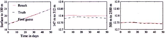
The quantity which is similar to the observations is the heat content along observational sections: in each run, its time evolution by vertical level is very well-estimated all over the assimilation period. The figure 4 represents the time series of heat content along the observational section HW3 for three layers to upper, intermediate and deep layers.
Figure 4 : Time evolution of the mean temperature along observational section HW3: comparison between the fisrt guess, result after assimillation and the 乪truth乫 used to simulate observations.
丂
5丂Conclusion
丂
Tomography is an efficient constrain for the ocean circulation described by the numerical model: it gives information about the heat content in the ocean interior over large distances at high temporal resolution. This information improves the estimation of the three dimensional circulation, mainly the baroclinic, large scale component of the field, but information is also transfered to smaller scales and barotropic mode by the model. These information are not available with other observational tools and can be complementary of the altimetric data. This work will be following by the assimilation of the tomographic data set obtained during Thetis 2 experiment in the western Mediterranean basin.
丂
Related papers
丂
Le Dimet, F., and O. Talagrand, 1986: Variational algorithms for analysis and assimilation of meteorological observations: theorical aspect. Tellus, 38A, 97-110.
Luong B., J. Blum and J. Verron, 1998: A variational method for the resolution of a data assrmilation problem in oceanography. Inverse problem, 14, 979-997.
Menemenlis, D., T. Webb, C. Wunsh, U. Send and C. Hill, february 1997: Basin-scale circulation from combined altimetric, tomographic and model data. Nature, 385, 618-621.
Send, U., 1996: Thetis 2, A Pilot Tomogragraphy System for Monitoring the Western Mediterranean Basin. Final Report.