2.0 Assumptions for the simulation study
This chapter summarizes studies from each WP and assumptions adopted by WP8 in order to implement the simulation.
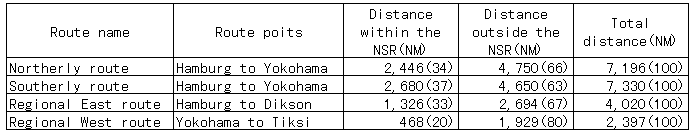
2.1 Route selections
WP1 performed detailed studies for route selection (Baskin et al., 1998). The following four routes are chosen;
・Northerly route
・Southerly route
・Regional East route
・Regional West route.
Northerly route links between Yokohama and Hamburg and suites for transit ships with a draft up to 12.5m and locates high latitude. Southerly route is also designed for transit ships with a draft less than 9.0m and lies along the conventional coastal route. Regional East and Regional West routes link between Tiksi and Yokohama, and Dikson and Hamburg respectively. Regional East and West routes aim to investigate transportation costs when economic development is realized in the future. Table 2.1.1 summarizes the distances of four routes.
The routes are plotted for every 20 nautical miles on sea charts taking into account ice conditions and water depth. When plotting routes, associated prime hazard and operational infrastructure along the routes are also identified. Figure 2.1.1 shows Northerly and Southerly transit routes. The Northerly route starts from Mys Zhelaniya Cape and passing Mys Archtichskiy Cape in the Kara Sea and north of the New Siberian Island. The Southerly route starts from the Karskie Vorota Strait and passing north of Belyy island, Dikson island, and through Vil'kitzkogo Strait and Sannikova Strait. Latitude and longitude and water depths of primary way-points are listed in Table 2.1.2 and 2.1.3. One must realize that some locations in the Laptev sea and the East Siberian are extremely shallow. Southerly and northerly routes in the NSR measure 2680 and 2446 nautlcal miles in distance respectively. Regional East route branches from Southerly route at point E1-01 locating 40, east of S-07 and goes down southerly by 122 N.M. to an entrance point of the port of Tiksi. Regional West route starts from S-02 locating an entrance point of Dikson and goes through the same routes as Southerly routes to Hamburg.