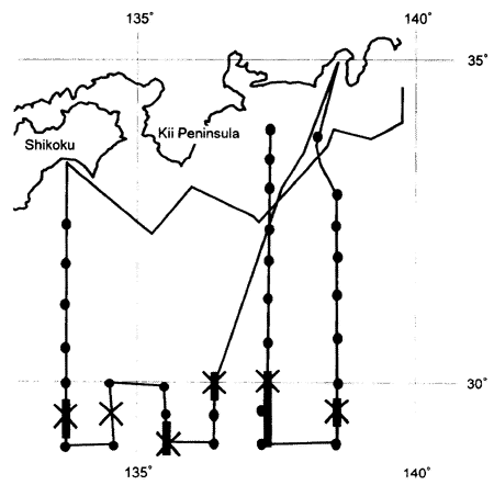
Fig.5 Site of the observations conducted by the R/V Takuyo of the Hydrographic Department Japan Maritime Safety Agency in May, 1981. The bold portions of the observation lines indicate that the abnormal saline water higher than 35.00 was found in the vertical section. Cross-marks indicate the place where the highest salinity value was found and/or where the stratum of abnormally saline water was found at its thickest in each north-south section.
N and 136゜18´E was also used as this point is located in the maximum temperature zone at the 200m level (see Fig. 3).
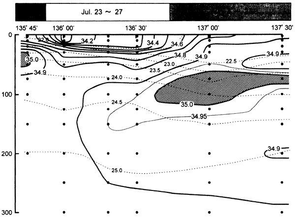
The abnormally saline water exists in mid-depths: from 50m to 110m in Soyo-maru lines and from 25m to 65m in Wakayama line. Though the depth ranges are different to each other, both abnormally saline waters are located in the similar density surfaces. This may suggest that both waters originate from the same source water. The fact that the abnormally saline water is separated by relatively less saline water, which was observed one week before, would suggest the temporal or spatial scale of the abnomally saline water is considerably small, and this would be related to its very low occurrence frequency discussed in the previous section.
Another difference in oceanic structures between August 1-2 and July 23‐27 is that a sharp seasonal thermocline exists in July, but it is significantly weakened in August. Takeuchi (1985) reported that a severe storm affected this area just before the observation time of the R/V Wakayama, The surface layer might have been mixed up and homogenized by storm. As discussed later, some of the abnormally saline waters extend up to the surface. It is highly possible that the abnormally saline water in the surface layer had disappeared due to the heavy precipitation and strong wind force.