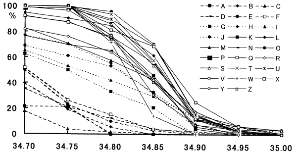
Fig. 2. Salinity values from 34.70 through to 35.00 at intervals of 0.05 were selected as reference salinity frequency of observations where salinities higher than each of these selected values was computed for each sub-domain frequencies in % are plotted against the selected salinity values. Identification of sub-domains are classified into three groups according to the decreasing manner of the frequency curve. See text for further details.
The temperature field at the 200m level is also shown in Fig.3. The cross-marks (areas of the highest salinity) are located at the temperature maxima in the north-south section at the 200m level, namely, just south of the strong current zone of the Kuroshio. Judging from the density structure below 200m depth, the flow would be directed eastward though its magnitude was considerably smaller. The high salinity water might be elongated in the east-west direction by this eastward current.
The salinity and density (sigma-t) cross-sections are shown in Fig. 4 along the line which is produced by connecting the cross-marks in Fig. 3. One additional datum at 32゜40'