Ice displacements observed by Synthetic Aperture Radar near the New Siberian Islands
Shinya Kakuta
Japan Marine Science & Technology Center, Yokosuka, Japan
Shoji Takeuchi
Remote Sensing Technology Center, Roppongi First Building, Tokyo, Japan
丂
1. INTRODUCTION
丂
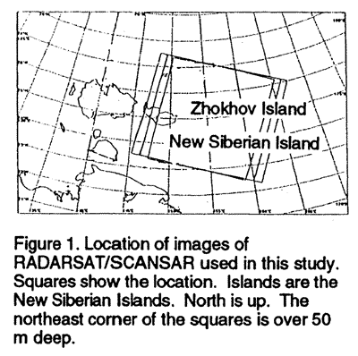
Preliminary RGPS (RADARSAT Geophysical Processor System) data set does not show data near the New Siberian Islands by the end of October, 1997, Thus, we investigated the region near the Islands by RADARSAT SCANSAR. Every week from December 1996 through April 1997, we obtained a 500 km* 500 km RADARSAT SCANSAR image in the Western half of the East Siberian Sea including the New Siberian Islands (Figure 1 and 2). This region is located on a continental shelf and adjacent to a shelf break. Indigirka Valley is also located in the region. The most part of this region is under 50 m deep. The northeast corner of this region is over 50 m deep. According to ice charts of National Ice Center, USA, land-fast ice extended over less than 20 m deep sea, that is, between the New Siberian Island and the Siberian Continent and 20 to 30 km northward offshore from the New Siberian Island. Trans-polar drift starts from this region. According to the results of basin-scale models (e. g. Flato and Hibler, 1992, Fig. 14), extensive sea-ice production is expected on the north of the New Siberian Islands. Thus, extensive brine production is also expected there. In contrast, Arctic sea-surface salinity is the lowest the East Siberian Sea.
丂
2. RADARSAT IMAGES
丂
Except land-fast ice, dark cracks of the RADARSAT images (Figure 2) may be regarded as thin-ice or open-water with 80 to 100 % of ice concentration (compactness), where brine may be generated. The dark cracks are sometimes over 30 km wide. The pattern of the dark cracks under a few km was changing drastically throughout the period of our RADARSAT observation. We also found that the pattern of the dark cracks over 10 km changed drastically, from December 29, 1996 to February 1, 1997 and from 14 to 28 April 1997. In contrast, a stable 50 km long dark portion with 90 to 100 % of ice concentration is located on the edge of land-fast be 70 km northeast of the New Siberian Island throughout the period of our RADARSAT observation.
丂
3. METHOD OF PATTERN MATCHING
丂
Ice displacements can be calculated from a pair of images of Synthetic Aperture Radar (SAR) with pattern-matching (e.g. Fily and Rothrock, 1987; Kwok et al., 1990). First, we average every 10 by 10 original pixels. The size of the averaged pixels was 500 m by 50O m for RADARSAT SCANSAR. Thus, the errors in relative velocity derived in this study are estimated as more than the size of this pixel averaging. Second, we match a pair of images without the image-pyramid method. The size of a window for area correlation is 15 by 15 averaged pixels. Search area for area correlation is restricted only to 31 by 31 averaged pixels.
To eliminate uncertainty in positioning pixels by orbital information of the satellites, ice-displacement vectors were calculated on image coordinates with the aid of an image tie point. In addition, to avoid the artifact for deformation by map projection, ice deformation parameters (divergence and shear) were calculated directory from the ice-displacernent vectors.
Since there is no data of drifting buoys on sea ice in the area of the RADARSAT images we used in this study, we have not verified the absolute velocity we derived from the images.