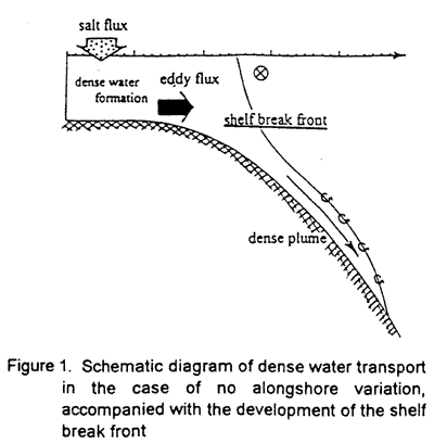
beyond a shelf break. A salinity front and surface left-bounded current on the front are developed over the shelf break, accompanied with the development of the bottom dense plume. The shelf break front is produced by the eddy flux. The location of the shelf break front was controlled by the depth and bottom slope. The depth and bottom slope are very important to decide a neutral point of the stability of the surface shelf break current. The shelf break front shows that the dense shelf water is prevented from being transported further offshore by the eddy flux.
丂
3. EFFECTS OF A SUBMARINE CANYON
丂
It is well known that dense shelf water is often transported to a basin through a canyon. The canyon is also recognized as a generation area of eddies which is measured in the Arctic basin. A mechanism of eddy generation near the canyon, however, has not been fully understood yet. A numerical experiment was carried out to clarify effects of a submarine canyon to the transport process of shelf water. In this experiment, the numerical domain has a submarine canyon in a region shallower than 500m depth, with 25km width at the mouth and 50km length from the mouth to the head.
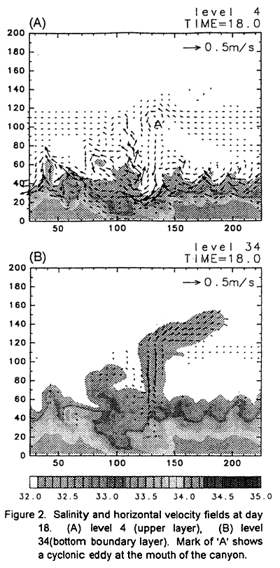
In the first stage of the experiment, a canyon plays a role of triggers of disturbances. Small cyclonic eddy is generated on the right side of the canyon with an offshore view. Then, the eddy gathers ambient dense shelf water and drives a bottom dense plume which flows into a canyon. The dense plume carries the dense shelf water offshore. On the other side, an anticyclonic eddy is generated firstly, then disturbances propagate toward left-bounded direction. The disturbances develop like an eddy development process shown in previous experiments. The development process, however, carries the dense shelf water offshore slower than the dense plume flowing into the canyon. These results are similar to the numerical experiments of Chapman and Gawarkiewicz (1995).
Figure 2 illustrates salinity and horizontal velocity fields for the numerical experiments at day 18. Level 4 (Figure 2a) and 34 (Figure 2b) is used as typical examples of the upper and bottom boundary layers, respectively. Figure 2b shows that bottom dense plume descending onto the canyon has already flowed to the slope region at day 18. On the slope region, the dense plume flows down from the mouth of the canyon with a right-bounded direction. Figure 2a shows the generation of a cyclonic eddy, which is marked 'A' around x=135km and y=110km. This location corresponds to not only the mouth of the canyon but also the place of the outflow of the bottom