・Work to increase crown height of sea revetments at Okushiri Port and installation of the watergates to address tsunamis and high tides in the Shiogama and Tsurikake rivers have been completed.
・Facilities, such as artificial reefs and submerged breakwaters with wide crowns, which are effective in reducing the height of tsunamis, should be considered in place of theexisting offshore breakwater.
4-2 Examination of regional disaster-prevention plans
(1) Conditions of examination
?Conditions of plans
Examination of the disaster- prevention area plans of Okushin Port will be based on the land- utilization plan which was examined for the Okushin Port Marine Town Project (MTP).
*The first phase improvement plan (10-year plan) within the MTP
Construction or improvement of ports/harbors: fishing port areas (outlying facilities, mooring facilities and cargo handling yards); reclamation and land development of old fishing port areas; quaywalls for cargo vessels (earthquake-resistant quaywalls); cargo handling yards, open- storage yards, landing quays, landing places, roads and greenery Construction or improvement of land facilities: community exchange center, sports center, fire station, underground sewage treatment facility, hotel, warehouse for fishing gear, cargo handling yards, oil reserve tanks.
?Prediction of tsunami runup heights for assumed future port layout
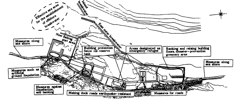
When examining land facilities, we assume the MTP plan to be the future port layout. The results shown in Fig. 4-1 indicate that the extension of the water area within the port is an effective measure to decrease tsunami runup height. Because of this, we schematically placed an offshore breakwater as a case study to predict the tsunami runup height (submerged height) that may enter inland. The runup height of such a tsunami was 4. 4 m at the maximum above the reclaimed land in the new fishing port area, and 4. 2 m at the maximum above the reclaimed land in the old fishing port area Figure 4-4 shows the layout of the port.
(2) Examination of inland disaster-prevention measures
The following and Fig. 4-4 show the results of the examination.
?Reclaimed land in the old fishing port area (Citizens' Communication Zone)
Based on the fact that the tsunami runup height is estimated to reach 4. 4 m at the maximum and that the planned facilities include public buildings of the town and fire stations, which are vital to the town's security, we suggest the following:
・Ground banking and raising building floors
・Building wave-resistant buildings
・To utilize the greenery area as a temporary refuge for the residents and as an emergency heliport, designate it as "disaster- prevention greenery area." For this purpose, the area should be banked and an artificial hill built.
?New fishing port area
This new port area is to be built in place of the reclaimed old fishing port areas. If banking is planned as a measure, height differences occur, resulting in inconvenience for use. For the above reason, an artificial foundation should be constructed here to provide a high plateau which can be utilized as the temporary refuge during tsunamis but would not hinder fishing operations under normal conditions.
・This area may be used as a refuge area during emergencies and as an observatory under normal conditions.
?Area behind the earthquake-resistant quaywall
The area behind the quaywall is planned to be used as a cargo handling yard and open storage yard for materials including sand, gravel and perlite, pottery, and daily supplies.
・Along with the consolidation of the ground against the liquefaction of reclaimed land, open space should be secured as a temporary stock yard for emergency rescue goods.
?Facilities for hazardous materials (oil reserve tanks)
Before building the facilities for hazardous materials, the influence of floating objects during tsunamis should be considered.
・The 2 oil reserve tanks owned by the town are not planned to be relocated at present. They should be secured by a wave- prevention fence.
The privately- owned oil reserve tanks are planned to be built on land owned by the town, which is located behind the earthquake-resistant quaywall, and it is advised that reclaimed land be protected by anti- liquefaction measures and banking of the ground be conducted.
Fig.4- 4 Inland measures(the 9th plan + reclamation of the old fishing port area + offshore breakwater)