area is 50m and the time interval is 1s. The tidal level in computation is T.P.(Tokyo Bay mean sea level) +0.80m. The estimated maximum tsunami height at the mouth of Suzaki port is 2.30m. The estimated maximum tsunami height at the innnermost part of the port is 6.0m.
(2) Graphics Image
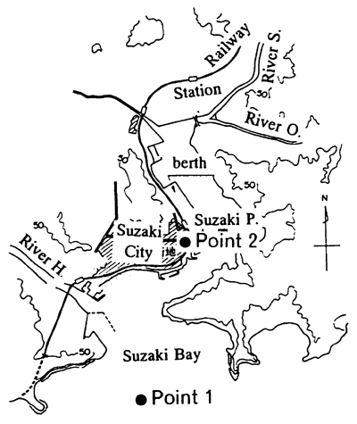
One of the characteristics of the developed computer graphic system is that the location and height of the observer's view point is changeable any time. The virtual image is observed only at the front of the wide screens. In the report we introduce some copies of the virtual reality images of the tsunami presented on a screen. Figure 5 shows the observation points in the Suzaki port. Point 2 is located in the most urban place in the city. The main buildings like the city office are concentrated in the vicinity of Point 2. Point I shows the construction site of the tsunami breakwater.
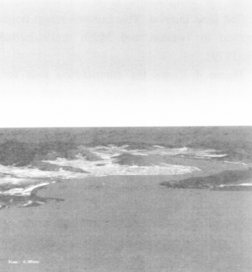
Figure 6 shows the bird's eye view image from Point I. The height above sea level of the view point is 500m. The time is about 40min after the earthquake shaking. The east part of the city area is flooded by the first wave of the tsunami.
Figure 7 shows the virtual reality image of an observer standing on a road near Point 2. Fig.7(1) shows the image before the earthquake. He is looking at the dry road, a monument at the right, a crossing forward and so on. Fig.7(2) shows the observed scenery 35mim after the shaking. The road is perfectly flooded by the runup tsunami and the lower part of the storehouse and monument are under water level. The image is effective to expect the damage by the tsunami runup. The residents in the city are able to have a virtual image to make alarm and refuge plans.
4. SEA WAVE GRAPHICS
(1) Wave Simulation
In shallow water, sea wave heights, direction may be transformed in the wave refraction, diffraction, shoaling, reflection and breaking. The Boussinesq equation model(Madsen,1992) has been employed to estimate wave heights in a port. The model is also applicable to evaluate the weak nonlinearity in shallow water region. The details of the model application is in the reference(Hiraishi,et.al.,1995). Fukaura-port located in the northern part of Japan was employed as the first trial of the virtual graphics for simulated waves.
Figure 8 shows the computation area for wave simulation. The area is represented in the grids with the unit length of 5m. In the computation, the directional random waves with the significant height H1/3 of 3m and period T1/3, 10s are given at the incident boundary 'Line I' at each time step. The time interval Δ t is 0.05s. Fukaura-port has a detached braekwater B1,