settled, was chosen as the model. To verify the exact distribution of artificial reefs, a preliminary survey was conducted by using the side scan sonar (Kline N530, 500 kHz) and laser position fixing unit (Atlas Ltd.) in July and September of 1992. To verify the distribution of the clusters in the model area, the survey lines were set at 200 meter intervals parallel with coast line in the hatched area in Fig.1, taking the effect of current and bottom topography into account. In order to measure accurately the positions of artificial reef clusters, the surveys were conducted from the boat sailing at the speed of 3.5 knots. Ship position was measured at every 10 minute intervals by laser position fixing system (POLARFIX, in Fig.2), which at present can give us the position with least error and variation.
With the assistance of these data of the corrected positions of tow-fish at respective moments, we have made a mosaic chart of the component blocks of artificial reef clusters, using the echogram of side scan sonar. The range of recording by the side scan sonar was set to be 150 m on one side (300 m on both sides) for making 100 m overlapped belt, and for preventing oversight of component blocks.
2.2 Acoustic and oceanographic survey
The main acoustic survey and oceanographic observation were conducted by the research boats, the Kuroshio (119 t) and the Kuroshio No.2 (16 t) in May and October of 1995. Acoustic information was collected with Furuno FQ-70 (50 kHz, 200 kHz) quantitative echo-sounder, interconnected to GPS systems. A SONY PC2O8A eight-track DAT recorder was used to store the analog output from the echo-sounder. The acoustic equipment was calibrated just before the start of survey, with a 38.1 mm diameter tungsten carbide calibration sphere.6) Echointegration was carried out between the 10m layer and sea-bed and sounder was operated with 0.6 ms pulse length and 2kW transmitter.
An ESDU (Elementary sampling distance unit) was defined to be 75 m. A systematic sampling design was applied with parallel transects to the coast line, separated by 200 m each.
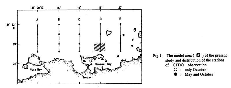
The oceanographic information was collected at the stations indicated in Fig.1. The temperature, salinity, contents of dissolved oxygen (DO) and density information from surface to near sea-bed were registered by a SBE-19 CTDO.
2.4 Geographic Information System (GIS)
GIS may be defined as the integration method of computer hard-and software with spatially referenced digital data so that new spatially related output is produced by storage, retrieval, manipulation, and analysis of the data7) Overlay technique is one of the most important functions in the GIS, which can allow us to fully visualize the spatial characteristics of various data, integrating multiple independent data. This approach also provides the effective method for understanding at a glance the relationship between acoustic data and other ones.8) As mentioned below, this technique was adopted as the preliminary step to the analysis of the relation between acoustic data and the environmental conditions, for the purpose of finding out the points to which attention should be paid during the analysis.