However many habitat surveys are needed in relatively remote areas where benchmarks are scarce so that obtaining horizontal control points is difficult. There is a definite advantage in using DGPS under these circumstances.
D. Remote Sensing
i. Intertidal
Tides on the B. C. coast typically range between 3 and 5 m, but at the heads of some fjords the range is up to 8m (Thomson 1981). In this region the lowest tides during daylight hours, when the water line is close to chart datum, occur for about a week in summer. Depending on the slope of the local shoreline, extensive areas of the intertidal habitat can be photographed or otherwise sensed from aircraft or satellites during this "window", contingent on sunlight and weather conditions. Protocols for aerial photography for mapping coastal habitat, particularly submerged aquatic vegetation, have been published by Dobson et al (1995).
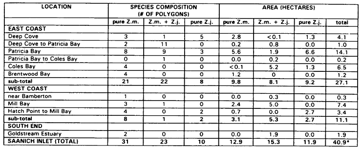
Because of large scale mapping requirements, low level colour or infrared photos combined with ground-truthing and DGPS have been used extensively in developing substrate and vegetation maps in our region. In a recent study of Saanich Inlet, on Vancouver Island, about 95 km of shoreline was mapped to compile a tabulation of the relative areas of two species of seagrass (Table 1). In this project colour air photos (scale 1:6000) were obtained on the lowest daytime tides in 1995. Field work for ground-truthing required about 20 person-days and included foot surveys on beaches, video, 35 mm photos, and direct observations from a small boat. As required, point or boundary data on the seagrass beds were registered with DGPS (Lessard et al 1996b). The polygons marked on the air photos were georeferenced, digitized, and overlain on standard terrestrial base maps as described in Durance (1996). The data were finally imported into the GIS Arcinfo for further analyses as required.
The Compact Airborne Spectrographic Imager (casi) was investigated in Baynes Sound, Vancouver Island, as an alternate method to aerial photography. Although casi is a more advanced technology it may not necessarily be more objective (North, 1996). casi records the reflectance of ground features and is able to distinguish different types of vegetation. The advantages of casi over air photos include:
- data are digital rather than analogue
- greater spectral range and possibility of setting spectral bands specifically, which may allow better discrimination of vegetation types
- possibility of detecting and discriminating submerged features (see below for possible application to subtidal surveys).
However, casi data must always be "trained" with ground-truthing and spectral records from various vegetation types. The spectral data from the instrument then need to be analysed and classified with various computer algorithms (including multivariate analyses), which are the choice of the
Table 1. Areas of polygons of eelgrass (Zostera marina and Zostera maria and Z. japonica) in several reaches of Saanich Inlet, British Columbia, mapped from aerial photos and ground-truthing in July 1995 (from Durrance 1996 and Lessard et al 1996b).