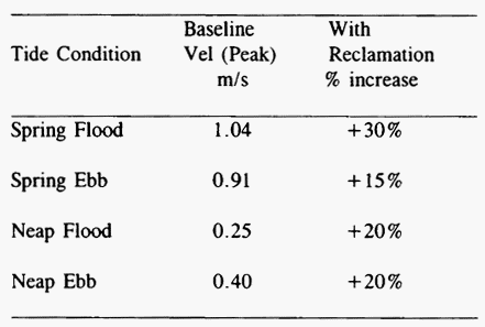
The fine grid local model was verified to ensure that it accurately reproduced field data relating to water levels and currents. The model was then used for assessing the impact of the reclamation on thehydraulic regime in the vicinity of the project site. Table 1 summarizes salient results.
Table 1 Comparison between peak velocities under Baseline and with Reclamation Conditions
The changes in the current velocities were generally localized in the vicinity of the reclamation. The changes in the water levels in the immediate vicinity of the reclamation were of the order of 2 to 3 cm whilst at about 1 km away from the reclamation they were about 1 cm only.
3.2.2 Physical Hydraulic Model Study
A physical hydraulic model study of the local region was carried out on a model scale of 1:500 (horizontal) and 1:100 (vertical) to study localized changes in the current pattern as well as the effect of the bridge structure (piers and islands) on the hydraulic regime of the surrounding waters. The boundary conditions for the physical model were derived from the fine grid numerical model.
The physical model was designed based on Freudian scale and was operated under the most critical spring Flooding tidal phase to simulate: (a) baseline (b) reclamation and (c) reclamation and bridge structure in place. The results of simulation showed that with the reclamation in place the additional effect of the bridge was very localized affecting mainly the flow in the vicinity of the bridge. The model was used to predict the changes in flow velocities in the vicinity of the reclamation. The velocity profiles predicted enabled the sizing of armor stones provided for the reclamation revetment as well as for the specification of some protection around the proposed bridge piers.
4. Mega Container Terminal Development at Pasir Panjang
4.1 General
Another case of sea space utilization relates to reclamation and development of a new mega-container terminal at Pasir Panjang in four phases spread over thirty years. The new container terminal will have fifty container berths with container handling capacity of up to 36 million TEUS. Figure 3 shows the proposed layout of the port development at Pasir Panjang. Engineering feasibility studies involving geotechnical, hydraulic and environmental were carried out to assess the suitability of the terminal at Pasir Panjang. The hydraulic studies involved wave propagation study and the tidal current and siltation studies.
4.2 Wave Model Study
The main objective of the wave study was to assess the wave conditions at the berths and vicinity of the proposed mega-container Terminal at Pasir Panjang. In this region waves are predominantly wind generated.
The proposed site at Pasir Panjang is sheltered against waves from the east during the North-east Monsoon by the land mass east of it but is affected by the South-west Monsoon. During the SW Monsoon relatively high waves are generated by winds blowing from west to south with wind speeds reaching upto 20 m/s for a brief period and gusts reaching up to 25 m/s. A major portion of these waves is blocked by the Jurong group of islands and refracted into Selat Sinki. The refracted waves are likely to be blocked by Cyrene Reefs and those reaching the Container Terminal are attenuated.
Wind generated waves at an offshore location were evaluated using the Sverdrup, Munk and Bretschneider wave hindcasting method. The wind generated waves were categorised into four sectors, namely west, south-west, south and south-east directions. Statistical analysis was performed and wave parameters forreturnperiods of 0.1, 1,5.10, 25 and l00year were generated.
Wave refraction analysis was carried out using MIKE 20NS to determine the wave climate at the proposed