|
3. SIMULATOR EXPERIMENT
3.1 Scenarios and Procedures
A simulator test experiment has been carried out on the ship handling simulator research facility of National Maritime Research Institute in order to subjectively evaluate VCASS for supporting HSC operators during navigation in congested waterways with difficult traffic conditions. The mock-up of an HSC bridge was installed with observation distance of about 5 m and was instrumented with steering stand and screen monitors for navigation and engine operation, Electronic Chart display System (ECS) and VCASS displays.
An expert mariner, with almost 40 years of sea experience as a navigator and a captain, participated as the main subject for the evaluation process. The test experiment was composed of 3 scenarios where own ship employed was the Techno-Superliner (TSL) operating with a nominal speed of nearly 40 knots in Tokyo Bay. The traffic flow was reproduced by SEATRAS. A daylight scene with clear visibility was created. The environmental conditions were no wind or current.
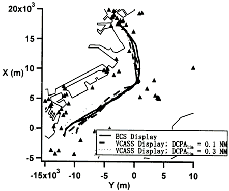
Each scenario was run twice with identical initial position of own ship in the innermost sector of Tokyo Bay. The traffic flow was different for each run. The first scenario was run with ECS display only, while the second and third were run with VCASS display with DCPAlim settings of 0.l (N = 10) and 0.3 n. miles (N = 3), respectively, and with TCPAlim of 3 minutes and λ = 1.5. Own ship was navigating through the traffic flow on a southbound course. Fig. 8 shows the actual tracks of own ship for the different scenarios.
Fig.8 |
Own ship tracks for the 3 scenarios that were carried out for the subjective evaluation of VCASS display for HSC operation in congested waterways. |
3.2 Subjective Evaluation Results
The expert mariner initially pointed out that passing astern of a target, which is normally preferred due to safety reasons, would require a minimum safety distance (DCPAlim) of about 0.1 n. miles while crossing ahead would require at least 0.3 n. miles for the TSL. TCPA limit (TCPAlim) of 3 minutes and vector length of 1 minute was found to be suitable parameters and chosen as default settings of VCASS.
The following were the results of the subjective evaluation by the expert mariner and group of researchers represented by the authors:
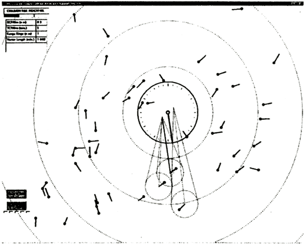
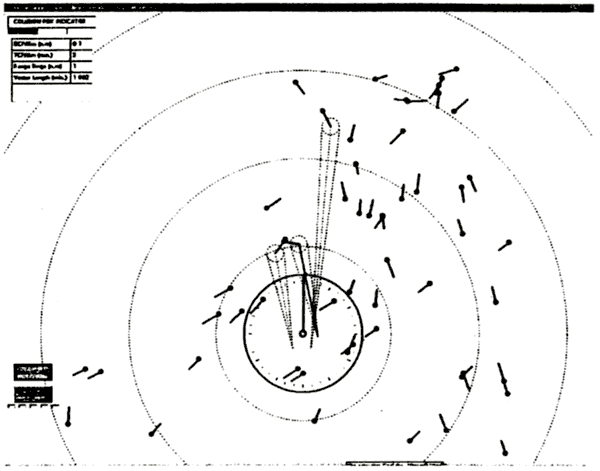
Merits: (1) VCASS display support early decision-making in complicated and congested traffic situations. Fig. 9 shows the mariner that own ship will pass in between (astern of) the NE and SW bound targets in the vicinity of the predicted track line of own ship with a DCPAlim = DCPAlim(here, 0.3 n.miles). The SW bound target vector is red (and its CDL is red solid) which indicates the DCPAlim and TCPAlim, are slightly violated to this target. The VCASS display therefore enables course-evasive maneuvers to be made well in advance of a developing situation. (2) The display is in particular useful in restricted visibility when the mariner cannot visually monitor changes in aspect ratio in the external world scene as targets are approaching. (3) The proposed target selection procedure was in accordance with the expert mariner's opinion of what targets were needed to pay attention to due to potential collision risk. Head-up display (Fig. 10) can be anticipated to be preferred by most mariners as it relates the display directly to the external world-scene.
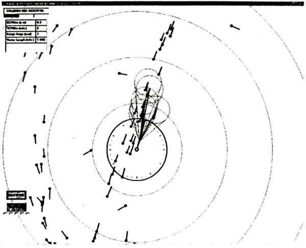
Demerits: (1) In head-on and overtaking situations the display of particularly CDL is not effective. This is illustrated in Fig. 11 where the TSL is overtaking several targets in a congested traffic lane. The display is overloaded and the CDS only could be considered sufficient for these situations. (2) The CDL should be considered as dotted (not solid) for targets violating the set safety limits as this is the usual display of lines known from ARPA systems. (3) In close quarter situations the mariners prefer to observe collision risk by visual observations as the change in aspect ratio can be immediately detected.
Proposals for Improvements: (1) The effect of a desired maneuver should be included by a display of relevant CDS prior to carrying out the maneuver. (2) The present display of target does not indicate the size of targets, which is important to consider for collision avoidance assessment. The target input to VCASS should therefore primarily be taken from the AIS, which includes ship length, and use radar data as supplement.
Fig.9 |
VCASS display with crossing targets: DCPAlim = 0.3 n.miles, TCPAlim = 3 min.,λ = 1.5. |
Fig.1O VCASS head-up display: DCPAlim = 0.1 n. miles, TCPAlim = 3 min., λ = 1.5.
Fig. 11 |
VCASS display in overtaking situation. DCPAlim = 0.3 n.miles, TCPAlim = 3 min., λ = 1.5. |
4. CONCLUSIONS AND FURTHER WORK
A Visualization-based Collision Avoidance Support System (VCASS), that focuses on presenting exact collision danger regions in true motion according to a suitable target selection procedure from the viewpoint of an HSC, has been developed and subjectively evaluated in a simulator test experiment by an expert mariner and team of researchers. Own ship employed was a large-size HSC operating in the heavily congested Tokyo Bay with a traffic flow density of about 250 ships operating simultaneously. It has been substantiated that VCASS is capable to support early decision-making of complicated and congested traffic situations and therefore enables course-evasive maneuvers to be made well in advance of a developing situation. Proposals for improvements of the man/machine interface have been made. A simulator test programme involving several expert mariners as subjects is planned for objective evaluation of the effectiveness of VCASS display for HSC operation in congested waterways.
ACKNOWLEDGEMENTS
The research has been supported by the Japan Society for the Promotion of Science (JSPS) through a post-doctoral fellowship to the first author. The work has been funded by the Ministry of Land, Infrastructure and Transport of Japan as a part of the Investigation on Technological Requirements for Fast Track Sea Lane project.
REFERENCES
[1] Egil Pedersen, Kinzo Inoue, Masanori Tsugane "Evaluation of a Radar Plot and Display Technique for Anti-collision Assessment of Multiple Targets in True Vector Representation by Application of the Environmental Stress Model", Journal of Japan Institute of Navigation, Vol. 106, pp. 1 - 12, 2002.
[2] Hayama Imazu, Junji Fukuto and Masayoshi Numano "Obstacle Zone by Target and its Expression", Journal of to Japan Institute of Navigation, Vol. 107,pp. 191-197, 2002.
[3] Hiroko Itoh, Masayoshi Numano and Egil Pedersen, "Modelling and Simulation of Sea Traffic and a Visualization-based Collision Avoidance Support System", Proc. of International Congress on Modelling and Simulation (MODSIM 2003), Townswille, Australia, 2003.
[4] Kuniji Kose, Kohei Hirono, Kenji Sugano and Isamu Sato, "A New Collision-Avoidance-Supporting-System and Its Application to Coastal-Cargo-Ship Shoyo Maru", Proc. of IFAC Conference Control Applications in Marine Systems (CAMS'98), pp. 169 - 174, Fukuoka, Japan, 1998.
[5] Masayoshi Numano, Hiroko Itoh and Yasujuki Niwa, "Sea Traffic Simulation and its Visualization in Multi-PC System", Proc. of International Congress on Modelling and Simulation (MODSIM 2001), pp. 2093 - 2098, Canberra, Australia, 2001.
|