|
PREDICTION APPROACH
In order to quantitatively evaluate the drifting trajectories of spilled oil the synthesized surface current vector is defined as the sum of the geostrophic current vector and the wind-induced drift vector described as follows.
Synthesized surface current vector = geostrophic current vector + wind-induced drift vector (4)
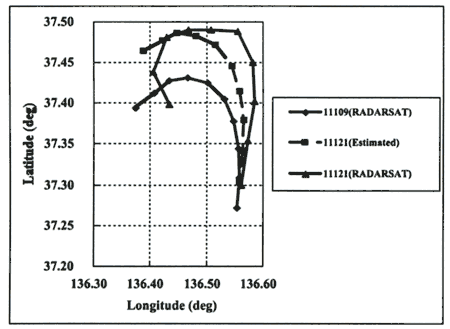
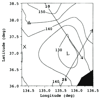
Figure 12 shows the variability of wind speed and direction at the buoy 21002 including the two RADARSAT times of data acquisition at January 1 1, 08h 52m and January 11, 21h 07m (UT). During the period of two RADARSAT overpasses the wind speeds are less than 4 m/sec and the wind directions are variable. That means the wind stress is not effectively working on the spilled oil or can be negligible in terms of wind-induced drift vector. So the prediction approach is limited to the geostrophic current vector applied for the two extracted RADARSAT signatures. Figure 13 indicates the result of comparison between the spilled oil signatures extracted from RADARSAT and the estimated trajectory based on the geostrophic current vectors from TOPEX/Poseidon. Ten locations along the initial spilled oil signature at January 11, 08h 52m(UT) are extracted and the locations after 12 hours are estimated by the geostrophic current vectors corresponding to each location. Predicted spilled oil trajectory based on geostrophic current vectors closely approximates the spilled oil signature extracted from RADARSAT in the eastern part of the study area. However in the western part of the study area around 37.4N and 136.4E the estimated trajectory does not follow the spilled oil signature in January 11, 21h 07m (UT). This may be attributable to the existence of the low sea surface topography or small-scale cyclonic eddy appeared in the estimated dynamic sea surface topography derived from TOPEX/Poseidon shown in Figure 14. Although there is a time difference of three to four days between the estimated topography and the RADARSAT spilled oil signatures, a counterclockwise eddy is observed next to the spilled oil signature in the RADARSAT image in January 11, 21h 07m (UT) shown in Figure 3. This small scale eddy with a diameter less than 100km is not resolved in the estimated sea surface topography from January 7-14, 1997 shown in Figure 8. It is recommended that the spatial and temporal scale of sea surface topography should be taken into account for resolving the small-scale eddy.
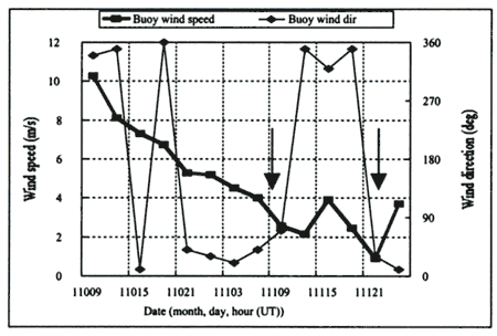 Figure 12. Variability of wind speed and direction at the buoy 21002 including
the two RADARSAT times of data acquisition (January 11, 08h 52m and January 11, 21h 07m (UT) indicated
as arrows)
Figure 13. Comparison between the spilled oil signatures extracted from
RADARSAT and the estimated trajectory based on geostrophic current vectors from TOPEX/Poseidon
Figure 14. Estimated dynamic sea surface topography derived from TOPEX/Poseidon
(cycle 159, orbit 10, 25) from January 7-8, 1997. (L represents relatively low dynamic sea surface
height unit: mm)
SUMMARY
The results of the study above are summarized as follows.
(1) Spilled oil trajectory is estimated by the combination of multiple satellite microwave sensors, namely RADARSAT, TOPEX/Poseidon and ADEOS/NSCAT.
(2) Predicted spilled oil trajectory based on geostrophic current vectors closely approximates the spilled oil signature extracted from RADARSAT.
(3) Small-scale cyclonic eddy appeared in the estimated sea surface topography from TOPEX/Poseidon in short temporal scale may affect the drifting path of spilled oil during the period of negligible wind influence.
ACKNOWLEDGEMENTS
The author would like to acknowledge Mr. Higashiuwatoko, a researcher in Remote Sensing Technology Center of Japan for providing RADARSAT and ADEOS/NSCAT data. The author also would like to express sincere gratitude to the following institutions and personnel for their helpful assistance in providing various datasets; Dr. Hirose of Kyushu University, the oceanographic department of Maizuru Marine Observatory, JMA, Maritime Safety Agency and NASA/JPL/PODAAC.
REFERENCES
Canadian Space Agency, NASA and RADARSAT International. 1994. RADARSAT ADRO Program Announcement Volume II RADARSAT System Description.
Espedal, H.A. and T. Wahl. 1999. Satellite SAR oil spill detection using wind history information. INT. J. REMOTE SENSING, 20(1):49-65.
Hirose, N. 1999. Assimilation of Satellite Altimeter Data with Circulation Models of the Japan Sea Ph.D thesis. Kyushu University.
Jacobs, G.A., PJ. Hogan and K.R. Whitmer. 1999. Effects of Eddy Variability on the Circulation of the Japan/East Sea. J. Oceanography. 55(2):247-256.
JPL Physical Oceanography Distributed Active Archive Center (PO.DAAC). 1997. MERGED GDR (TOPEX/Poseidon) Generation B USER'S HANDBOOK Version 2.0.
Kozai, K. 1999. Variation of satellite-derived sea surface topography in the southern part of the Japan Sea including the drifting period of Nakhodka bow section. J. of the Marine Meteorological Society (UMI TO SORA), 75(2):21-34. (in Japanese)
Kuragano, T. and A. Shibata 1997. Sea Surface Dynamic Height of the Pacific Ocean Derived from TOPEX/Poseidon Altimeter Data: Calculation Method and Accuracy. J.Oceanography. 53(6):585-599.
Lee. J.S. 1983. A Simple Speckle Smoothing Algorithm for Synthetic Aperture Radar Images. IEEE Trans. System, Man and kinematics. 13(1):85-89.
Lillesand, T.M. and R.W. Kiefer. 2000. REMOTE SENSING AND IMAGE INTERPRETATION. 4th Edition. New York: John Wiley & Sons, Inc.
Menkes, C., JP. Boulanger and A.J. Busalacchi. 1995. Evaluation of TOPEX and basin-wide Tropical Ocean and Global Atmosphere-Tropical Atmosphere Ocean sea surface topographies and derived geostrophic currents. J. Geophys. Res. 100, 25087-25099.
National Space Development Agency of Japan (NASDA) (ed). 1997. Observation of spilled heavy oil from airborne and satellite sensors. A report of investigation by satellite remote sensing for the Nakhodka oil spill accident (in Japanese).
Polito, P.S. and P. Cornillon, 1997. Long baroclinic Rossby waves detected by TOPEX/Poseidon. J. Geophys. Res. 102(C2):3215-3235.
Shepherd, N. 1997. Extraction of Beta Nought and Sigma Nought from RADARSAT CDPF Products, ALTRIX Systems.
Strub, TP., T.K. Chereskin P.P. Niiler, C. James and M.D. Levine. 1997. Altimeter-derived variability of surface velocities in the California Current System. J. Geophys. Res. 102(C6):12727-12748.
Thiebaux, H.J. and M.A. Pedder. 1987. SPATIAL OBJECTIVE ANALYSIS: with application in atmospheric science. Academic Press.
|