|
SHORELINE CHANGE DUE TO CONSTRUCTION OF INTAKE BREAKWATERS OF WOLSUNG NUCLEAR POWER PLANT
Kyung-Duck Suh1 and Yong-Taek Oh2
1School of Civil, Urban, and Geosystem Engineering
Seoul National University Seoul, KOREA
kdsuh@snu.ac.kr
2Korea Port Engineering Corp.
Seoul, KOREA
dragon5@korea.com
ABSTRACT
The Naari beach located at the southern part of the east coast of Korean Peninsula has experienced severe shoreline change during the first several years after the construction of the intake breakwaters of the Wolsung Nuclear Power Plant. The beach was largely accreted at the northern part, while severe erosion occurred at the southern part, eventually causing damage of the seawall behind the beach. In the present study, we analyze the shoreline change using aerial photographs taken before and after the construction of the nuclear power plant. Also a curvilinear-coordinate shoreline evolution model combined with a Cartesian-coordinate wave model is used to calculate the shoreline change, which is compared with the observed shoreline change through the analysis of the aerial photographs.
INTRODUCTION
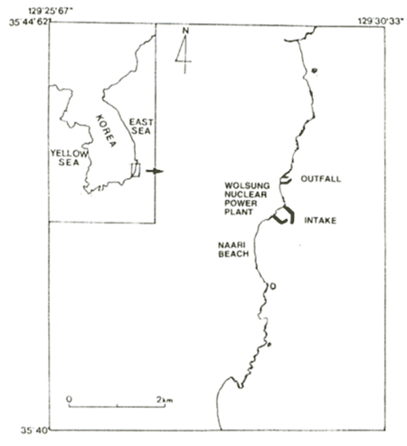
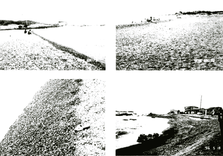
The Wolsung nuclear power plant is located at the southern part of the east coast of Korean peninsula as shown in Figure 1. It has intake breakwaters in the south, and outfall breakwaters in the north. The Naari beach is located to the south of the nuclear power plant. The intake breakwaters were completed on September 24, 1979. After the intake breakwaters were constructed, severe erosion occurred at the southern part of the Naari beach, whereas severe accretion occurred at its northern part. Figure 2 shows several photographs of the beach. The upper left photo is the view from the center of the beach to the north. The power plant buildings are shown in the middle, and the intake breakwaters extended to the right. The upper right is the view from the center of the beach to the south. The lower right shows the southern end of the beach, where the beach is very narrow because severe erosion occurred there. The beach material consists of gravel and coarse sand on the beach as shown in the lower left photo, but it changes to fine sand in deeper water.
The purpose of the present study is to calculate the shoreline change using
a numerical model and to compare the results with the measurement. Because there is no direct measurement
data of the shoreline change, we used the aerial photographs taken by the National Geography Institute,
Ministry of Construction and Transportation, Korea, before and after the construction of the nuclear power
plant. A curvilinear-coordinate shoreline evolution model combined with the RCPWAVE model ( Ebersole
et al., 1986) is used to calculate the shoreline change. The wave hindcasting data of the Korea Ocean
Research and Development Institute are used to provide the RCPWAVE model with the offshore boundary wave
conditions.
Figure 1. Site map of Wolsung nuclear power plant and Naari beach
Figure 2. Photographs of Naari beach
ANALYSIS OF SHORELINE CHANGE USING AERIAL PHOTOGRAPHS
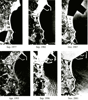
Figure 3 shows the aerial photographs taken by the National Geography Institute almost every five years. We can see that the intake breakwaters were expanded between 1993 and 1996. In the photographs taken in 1993 and 1996, it is very hard to read the shoreline data because of severe wave breaking. Therefore, these were not included in the analysis of shoreline change.
Figure 3. Aerial photographs
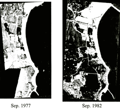
We cannot immediately use the aerial photographs as shown in Figure 3 because each of them was taken from a different altitude and at a different angle. In order to make use of the aerial photographs, first we have to make the geometric correction of the original photographs such that the image of the photograph and the real topography become similar figures. This correction process is called rectification. We used the image-processing program, Imagine version 8.4 of ERDAS, digital maps, and topographical maps of 1:5,000 scale for the rectification. Figure 4 shows examples of the rectified image of the photographs. As one can see, between 1977 and 1982, severe erosion occurred at the southern part, whereas severe accretion occurred at the northern part.
Figure 4. Rectified images of aerial photographs
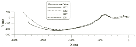
Figure 5. Shoreline change between 1977 and 2001
Figure 5 shows the shoreline change between 1977 and 2001. The shoreline changed significantly between 1977 and 1982, but only minor change occurred after 1982. Since the intake breakwaters of the nuclear power plant were completed in 1979, we could say that the significant shoreline change was caused by the construction of the intake breakwaters. Therefore, in this study, we calculate the shoreline change for the three years from September 1979, when the intake breakwaters were completed, to October 1982 when the first aerial photograph was taken after the construction of the breakwaters.
|