|
DESIGN OF SAND TRAP AT VISAKHAPATNAM
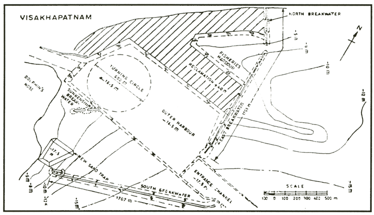
The ancient Visakhapatnam Port located on the east coast of India was an inland port connected to the sea by a long navigation channel. It was well protected from waves by a natural geographical configuration. Presence of bedrock at shallow depths below sea level precluded economical expansion of the port for modern deep-draft vessels up to 150,000 DWT having drafts up to 15 m. It was therefore decided to construct a new outer harbor enclosed by long breakwaters for wave protection. While littoral transport occurs in both directions at this site, the predominant direction is northward. Hence construction of a shore-connected breakwater would result in large accumulation on the south side, eventually resulting in sand bypassing into the navigation channel after a few years. It was proposed to provide a gap between the shoreline and south breakwater and locate a sand trap within the gap (Fig.6) for trapping littoral drift.
Parchure (1978) has described the studies conducted at the Central Water and Power Research Station, Pune, India for a new sand trap designed for the Visakhapatnam Outer Harbor. Quantitative estimation of littoral drift was a major component of this study. Wind data for the past several years were obtained from the India Meteorological Department. These were analyzed and wind rose diagrams were plotted. Wave rose diagrams were constructed using wind and fetch data in the hindcasting techniques. Wave data reported for ships from offshore locations were used for validation. Wave-induced sediment transport was computed by adopting methods recommended in the Shore Protection Manual (1984) and site-specific correlations were established between the wave energy and littoral drift rates. It was estimated that for an average annual wave climate, the net northward littoral drift would be 700,000 cu m.
Movable bed model studies were conducted on a wave-current physical model having horizontal and vertical scales of 1:240 and 1:80 respectively. Crushed walnut shells having a specific gravity of 1.36 and a median diameter of 0.6 mm were used as bed material. Field data on shoreline changes and quantities of sediment collected in the existing sand trap were used for model validation. After testing several layouts for a sand trap, the final layout shown in Figure 6 was recommended. It had a volumetric capacity of 600,000 cu m, and a bed level of 17.5 m below sea level. It was estimated that the south breakwater would arrest 21 percent of littoral drift, while the new sand trap will catch 66% and the remaining 13% would bypass the system. The new sand trap has been functioning successfully since its construction in the late 1970s.
ACKNOWLEDGMENT
Permission was granted by the Chief of Engineers to publish this paper.
REFERENCES
Bobb, W.H. 1965. Effects of proposed dikes and sediment traps on shoaling and currents in tidewater's Delaware city channels, Miscellaneous Paper No.2-723. U.S. Army Engineer Waterways Experiment Station, Vicksburg, MS.
Bobb, W.H. 1967. Results of Hydraulic and Shoaling Studies in Marcus Hook - Schuylkill Reach of Delaware River, Miscellaneous Paper No.2-887, U.S. Army Engineer Waterways Experiment Station, Vicksburg, MS.
Herb, W.J. 1980. Sediment-trap efficiency of a multiple-purpose impoundment, Report, North Branch Rock Creek Basin, Montgomery County, Maryland, 1968-76.
Hobson, R.D. 1982. Performance of a sand trap structure and effects of impounded sediments, Channel Islands Harbor, California,
Jarrett, J.T. 1988. Beach fill and sediment trap at Carolina Beach, North Carolina, Technical Report CERC-88-7, U.S. Army Engineer Waterways Experiment Station, Vicksburg, MS.
Larson, M. and N.C, Kraus. 2001. Estimation of suspended sediment trapping ratio for channel infilling and bypassing, ERDC/CHL CHETN-IV-34, U.S. Army Engineer Research and Development Center, Vicksburg, MS.
Parchure T. M. 1978. Movable Bed Model Studies for Visakhapatnam Outer Harbour Project. Proceedings of 47th Annual Research Session of Central Board of Irrigation and Power, India.
Parchure, T.M., B. Brown, and R.T. McAdory. 2000. Design of sediment trap at Rollover Pass, Texas, ERDC/CHL TR-00-23, Coastal and Hydraulics Laboratory, U. S. Army Engineer Research and Development Center. Vicksburg. MS.
Parchure, T.M. and A.M. Teeter. 2002a. Lessons Learned from Existing Projects on Shoaling in Harbors and Navigation Channels, Technical Note (in preparation). Coastal and Hydraulics Laboratory. U.S. Army Engineer Research and Development Center. Vicksburg. MS.
Parchure, T.M. and A.M. Teeter. 2002b. Potential Methods for Reducing Shoaling in Harbors and Navigation Channels, Technical Note (in preparation), Coastal and Hydraulics Laboratory, U.S. Army Engineer Research and Development Center, Vicksburg, MS.
Rosati, J.D. and N.C. Kraus. 1989. Development of a portable sand trap for use in the nearshore, Technical Report CERC-89-11, U.S. Army Engineer Waterways Experiment Station, Vicksburg, MS.
Shore Protection Manual. 1984. U.S. Army Engineer Waterways Experiment Station, Government Printing Office, Washington, DC.
U.S. Army Engineer Waterways Experiment Station, 1963, Savannah Harbor Investigation and Model Study: Vol.III, Results of model Investigations, Section 3, Results of Supplemental Tests. Technical Report No.2-580, Vicksburg, MS.
| (Enlarge: 35KB) |
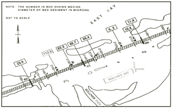 |
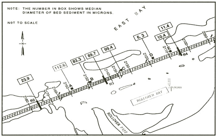
Figure 1. Bed material size in GIWW at Rollover Pass
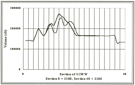
Figure 2. Historical dredging quantities in GIWW
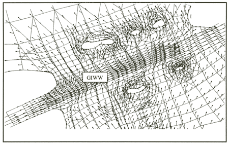
Figure 3. Flow pattern during flood tide
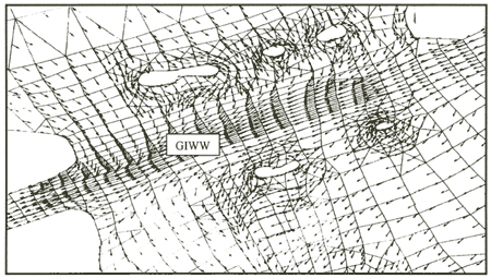
Figure 4. Flow pattern during ebb tide
| (Enlarge: 28KB) |
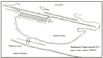 |
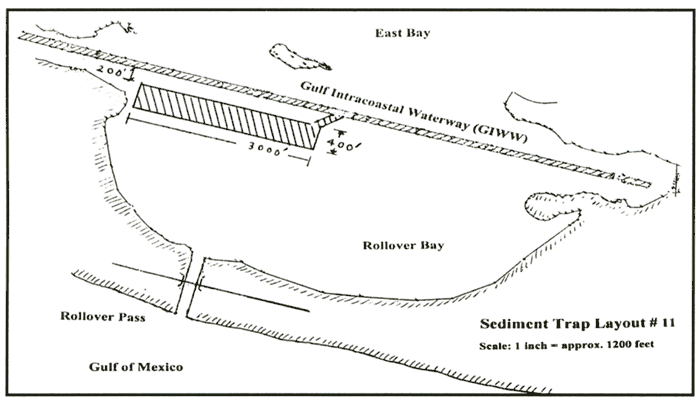
Figure 5. Sediment trap recommended at Rollover Pass
| (Enlarge: 100KB) |
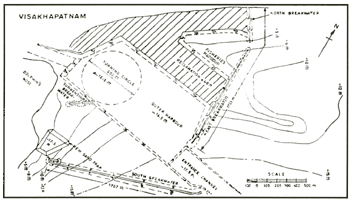 |
Figure 6. Sediment trap at Visakhapatnam Port
|