|
The effects after the construction of Isahaya Dike
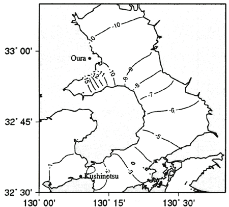
The Ariake Sea is the top "Nori" growing region in Japan, accounting for nearly 40% of total production. However, this year the area suffered a poor harvest and may decrease output by 50 percent. The unusually red tide which used up all the nutrients in the water turning the seaweed from a healthy black to a sickly yellow was often occurred. The red tide in the Ariake Sea seems to be connected with the government's reclamation project in Isahaya Bay. The construction of Isahaya Dike was started in 1988 and completed in 1997. The part of Isahaya Bay was closed to reclaim 3,550 hectares of land, and the contaminated water is regularly discharged from a reservoir inside the gates. Therefore the mean sea level in West Japan was increased by 10 cm during 1985-1999 and tidal amplitude was decreased. The observed tidal amplitude decreased by 3 cm (Kuchinotsu) and 6 cm (Oura) during 1974-1999 in the Ariake Sea, and the tidal amplitude in Isahaya Bay has decreased over 10 cm after the construction of Isahaya Dike. These changes are about 2-3% effects of total tide. Observed data was effective from Isahaya Dike and other reclamations, but this study is considering only the effect of Isahaya Dike. The decrease of the tidal amplitude, in the major eight tidal constituents, was computed to be 1.84 cm at Kuchino station and 9.83 cm at Oura station (Fig.8).
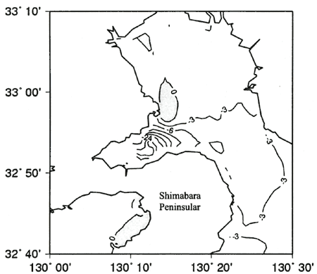
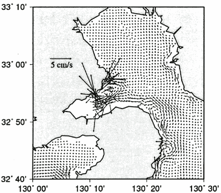
The difference of maximum current magnitude is increased at the north part of the entrance of Isahaya Bay, and decreased at the around of Shimabara peninsula (Fig.9). This computational result is similar to the result of Nadaoka (2002) and Unoki (2001). Figure 10 shows the change of eddy with the reduced current, specially, in the middle of Isahaya Bay. Isahaya Bay seems a cavity, so the eddy forms in Isahaya Bay was changed by the construction of Isahaya Dike.
Figure 8. The difference of tidal amplitude before and after the construction
of Isahaya Dike (in unit of cm)
Figure 9. The difference of maximum current magnitude of M2
constituent before and after the construction of Isahaya Dike (in unit of cm/s, the gray part shows increasing)
Figure 10. Difference of tidal residual flow (8 constituents) before and
after the construction of Isahaya Dike
SUMMARY
The parallel version of a three-dimensional primitive equation model was set up to study the tidal current in the Ariake Sea. The tidal simulation computed effectively in the parallel Linux system, and compared observed tidal harmonic constants and residual currents in the inner Ariake Sea. But, exact bathymetric data for computation are not enough, especially for the tidal flat area. This model does not include the tidal flat solving computation with moving boundaries. It seems to cause overestimation of the tidal elevation in the inner Ariake Sea. For examining the effects of the construction of the sea dike in Isahaya Bay on the changes in tide and current in the Ariake Sea, an attempt has been made to perform the tide simulation. Tidal amplitude in Isahaya Bay has decreased over 10 cm, these changes are about 2-3% effects of total tide, and tidal current has decreased after the construction.
This study about tidal simulation by parallel POM is in the first stage of establishing the comprehensive model for mesoscale air-sea circulation by coupling the third-generation ocean wave model, the three-dimensional ocean circulation model and mesoscale atmospheric model. Seawater circulation is the basis of predictions of pollutant diffusion, sediment transport from the rivers, sea bottom changes as well as seawater exchange. Dominant external forces for water circulation are winds, waves and tides that generate wind-driven and wave-driven currents with three-dimensional structure. Future work will make progress in coupling of water circulation, waves and winds.
REFERENCES
Choi, B.H., K.O. Kim and H.M. Eum. 2002. Digital bathymetric and topographic data for neighboring seas of Korea (in Korean) J. KSCOE. 14(1):41-50.
Hukuda, H., J.H. Yoon and T. Yamagata. 1994. A tidal simulation of ariake bay - a tideland model, Journal of Oceanography 50:141-163.
Japan Coast Guard. 1992. Tidal harmonic constituents tables - Japanese coast. Japan Coast Guard.
Mellor, G.L. and T. Yamada. 1982. Development of a turbulence closure model for geophysical fluid problems. Reviews of Geophysics and Space Physics. 20(4):851-875.
Nadaoka, K. 2002. Influence of the Isahaya Bay sea-dyke on the changes in tide, currents and water quality in Ariake Sea. In The 51th National Congress of Theoretical & Applied Mechanics 2002. PD1-8.
Oberpriller, W, A. Sawdey, M. O'Keefe, S. Gao and S. Piascsek. 1998. Parallelizing the Princeton Ocean Model Using TOPAZ. http://topaz.lcse.umn.edu.
Sanyo Techno Marine Inc. 1993. A report on tidal analysis in Ariake Kai fishing grounds (in Japanese) Sanyo Techno Marine Inc.
Simons, T.J. 1980. Circulation models of lakes and inland seas. Can. Bull. Frsh. Aquat. Sci. 203:146.
Unoki, S. 2001. The change of water elevation and current in the Ariake Sea. In Kyushu-Okinawa Joint Symposium - the oceanic environment in the Ariake Sea.
|