|
Electronic Products
Electronic Charts Explained
A major development initiative from the Australian Hydrographic Service
Royal Australian Navy
Australian Navigational Charts
The Australian Hydrographic Service (AHS) is a part of the Royal Australian Navy and Australia's national charting authority. The AHS has been responsible for providing Australia's official navigational charts for over 75 years. The Service publishes nearly 400 charts, providing the most comprehensive coverage of Australia's seas and oceans available anywhere.
Electronic Charting
Electronic chart navigation can be considered under two main headings: ECDIS and ECS.
ECDIS
Electronic Chart Display and Information System
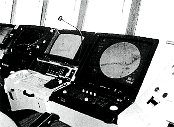
ECDIS is much more than simply images of a chart on a computer screen. It provides a powerful decision making tool on the bridge of a ship by combining satellite and other position fixing with ship's sensors and a sophisticated electronic database containing charting and other navigation information.
A typical ECDIS installation in a ship
The chart information in ECDIS is continuously analysed and compared with a ship's position, intended course and its maneuvering characteristics to give warning of approaching dangers. ECDIS also provides alerts and prompts for planned course alterations. Additional material, such as photographs and views, as well as navigational notices and cautions can be accessed instantly and displayed as required on high resolution full colour screens . In addition, ECDIS provides many other sophisticated navigation and safety features, including continuous data recording for later analysis.
In the near future, ECDIS will also incorporate and display information contained in other nautical publications such as Tide Tables and Sailing Directions and incorporate additional maritime information such as radar information, weather, ice conditions and automatic vessel identification.
The chart database used in ECDIS is known as an Electronic Navigational Chart (ENC). ENCs and their updates are only published by or under the authority of governments. As such, they carry full official status and the backing of the issuing government.
The chart information in an ENC is not held as a single image or "picture" of a chart, but as individual items (vectors) in a database. Each chart feature and its associated information is recorded separately in the database. This allows all the chart data to be analysed and re-assessed continuously by ECDIS in relation to a ship's current and intended position. Dangers or hazards which will affect a ship can then be identified automatically and warnings and alarms raised.
ECDIS supports a comprehensive update mechanism to ensure ENCs can be kept up to date, with things such as Notices to Mariners. Chart maintenance is achieved in effect automatically via disk update, e-mail message or satellite data transfer.
The versatility of the ENC vector chart database and the comprehensive ECDIS display and performance standards allow the mariner to select and display navigational information most relevant to the requirements and the situation at the time. For example, ECDIS will display and respond to the safety depth contour based on a vessel's actual draft. The level of chart detail that is shown can also be adjusted according to the circumstances and alternative colour schemes can be selected for use by day or by night.
ECDIS and ENCs must conform to rigorous standards regarding how they operate and what information is displayed. The standards govern such things as chart data structure, minimum display requirements and minimum equipment specifications as well as many other aspects. The International Hydrographic Organization (IHO) and the International Maritime Organization (IMO) set the ECDIS and ENC standards.
Legal Status of ECDIS
When used in an IMO compliant ECDIS systems, Official ENCs (and Official RNCs for those areas not yet covered by ENCs) will allow vessels navigating in Australia to meet the strict electronic chart carriage requirements of SOLAS Chapter V.
ECDIS "Dual fuelling"
After many years of development the Australian Hydrographic Service released its first commercial ENCs on July 1, 2002. This complements its Raster Navigational Chart product - Seafarer RNC - released in 1997.
However, as there is so much more information in an ENC than in a paper chart, it will take some time to provide full coverage for the whole of Australia. To overcome this shortfall, the IMO has approved a Raster Chart Display System (RCDS) mode of operating ECDIS for use in those areas where ENCs have not yet been produced. The RCDS mode of operation is sometimes referred to as ECDIS "duel fuelling".
RCDS mode relies on RNCs, instead of ENCs. RNCs are scanned images of official paper charts and like ENCs are only published under the authority of governments and their hydrographic offices. RNCs can provide some, but not all of the functions of ENCs.
Australia's RNCs are known as Seafarer(R) RNC charts. They are scanned images of the official Australian paper charts and are published by the AHS on CD-ROM. They contain exactly the same information as official paper charts and maintain the same standards of quality, reliability and government backing. Like ENCs and paper charts, they are supported by a Notice to Mariners update service. Seafarer(R) RNC uses Hydrographic Chart Raster Format (I-ICRF), which is the same format and standard used by the British Admiralty.
RNC and ENC Availability
Australia's RNCs are published by the Australian Hydrographic Service as Seafarer(R) RNC charts. A list of suppliers can be obtained from the AHS or the AHS website . Chart updates can be obtained by subscription and are supplied monthly on CD-ROM. This allows Notices to Mariners to be applied to RNCs virtually automatically.
Australia's RNCs are published by the Australian Hydrographic Service as Seafarer(R) ENC and are available from the network of Seafarer Product Distributors. Updates are available through the AHS website or, if required, can be supplied on CD-ROM.
ECS
Electronic Chart Systems
All electronic chart systems other than ECDIS are known simply as ECSs (Electronic Chart Systems). ECSs provide automatic plotting of a vessel's position on an electronic chart of some sort. Some ECSs provide many of the functions found in ECDIS such as route planning, route monitoring and the raising of alarms and warnings. ECSs are particularly popular with professional fishermen, small charter vessels and recreational boaters. "Chart Plotters" are ECS's. Two typical ECSs are shown below and to the right.
The charts used in ECSs come in a variety of forms. Some ECSs use RNCs while others rely on commercially produced charts ranging from very simple line drawing to images that closely resemble paper charts or ENCs. Commercial charts have no government backing or endorsement. ECS screen displays vary also. Some are small and single colour, others run through a standard PC or laptop and can provide full colour and more detail.
Legal Status of ECS
There are no agreed standards for ECSs or the versions of the charts that they use. Because of this, ECSs are NOT recognised as an alternative to paper charts where charts are required to be carried under Australian or International Regulations.
Glossary of Terms
IHO - International Hydrographic Organization, the organisation which coordinates world hydrographic charting policy and standards.
IMO - International Maritime Organization, the United Nations organisation which coordinates safety policy and standards for world shipping.
SOLAS - Safety of Life at Sea Convention - the principal international convention regulating ship safety. Administered by IMO.
ECDIS - Electronic Chart Display and Information System - highly sophisticated navigation systems designed for ships. Must conform to strict international standards.
ENC - Electronic Navigational Chart - vector chart data base published by a national hydrographic office for use in ECDIS. Must meet international standards set by the IHO and IMO. ENC data is arranged according to S57 format and specifications.
S57 - The IHO data format and specification which governs the content, creation and display of ENCs.
RCDS - Raster Chart Display System - a mode of operation for ECDIS which uses official raster charts (known as RNCs) in areas where ENCs have yet to be produced by Hydrographic Offices.
ECS - Electronic Chart Systems - non-ECDIS chart navigational systems, some of which come close to ECDIS performance.
RNC - Raster Navigational Chart - an electronic facsimile of an official paper chart for use in ECD1S RCDS mode and for RNC capable ECSs. The Australian Hydrographic Service publishes its RNCs under the name of Seafarer(R).
More Information
Manager Products & Services,
Australian Hydrographic Office,
Locked Bag 8801,
South Coast Mail Centre,
NSW, 2521, Australia.
Fax: +61 (0) 2 4221 8597
E-mail: hydro.marketing@defence.gov.au
|