コロラド大学による海面高度分布速報データの利用について
前川陽一*・内田誠*・永田 豊**
*三重大学生物資源学部附属練習船勢水丸
**(財)日本水路協会海洋情報研究センター
三重大生物資源紀要
第27号:1〜15
平成13年10月31日
平成13年6月29日受理
*514-2221三重県津市高野尾町2072-2
**104-0061東京都中央区銀座7-15-4三島ビル5F
Utilization of the near-real-time altimeter data
given by Colorado Center for Astrodynamics
Research of University of Colorado
Yoichi MAEKAWA*, Makoto UCHIDA*, and Yutaka NAGATA**
*Training/Research Vessel Seisui-maru, Faculty of Bioresources, Mie University
**Marine Information Research Center, Japan Hydrographic Association
Abstract
Colorado Center for Astrodynamics Research of University of Colorado (CCAR) publishes near-real-time TOPEX/POSEIDON (T/P) and ERS-2 altimeter data through its WWW site every three days, The sea surface dynamic height (SSDH) level distribution in Japan and its neighboring waters is distorted due to the limited accuracy of the standard geoid surface, so that the Kuroshio path is hardly detectable, However, it is useful for detecting the generation, movement and disappearance of oceanic meso-scale eddies near the Kuroshio path, The techniques for utilizing the satellite altimeter data are discussed with special reference to the warm eddies found off the Enshu-nada sea, along the pacific coast of central Japan, for the period from January 2000 to March 2001.
Key words : Near-real-time altimeter data ・ Sea level distribution ・ CCAR of University of Colorado ・ warm eddies off Enshu-nada ・ small scale meander of the Kuroshio
1 はじめに
コロラド大学の工学・応用科学部(College of Engineering and Applied Science)にある宇宙力学研究コロラドセンター(CCAR : Colorado Center for Astrodynamics Research)では,TOPEX/POSEIDON(T/P)およびERS-2のふたつの衛星による海面高度計の資料から求めた世界の海面高度分布を,準リアルタイムでウェブサイトを通して提供するサービスを行っている。地衡流のバランスの下で流れている海流は,海面の等高線に沿って,等高線密度に比例した速さで流れるから,正確な海面高度資料から直接に,船舶の運航に役立つ情報が得られるはずである。コロラド大学の解析は世界を対象としたものであるが,基準となるジオイド面の正確な推定は,現状ではカリブ海と湾流域を除いて行われていない。黒潮域等については基準となるジオイド面の決定精度が十分ではなく,ガルフストリームと違って,黒潮流路の再現も成功していないのが現状である。しかし,黒潮周辺の暖水塊や冷水塊の消長等のような小規模短周期現象については,前後の画像との比較から,有意義な情報を得ることは可能であり,三重県科学技術振興センター水産研究部や和歌山県農林水産総合技術センター水産試験場あるいは,(財)日本水路協会海洋情報研究センター(海洋情報室)等では,漁海況速報あるいは海況速報の作成の際に,この衛星高度計による高度データを参考にしている。
衛星を用いた計測は,広域な海況のリアルタイム情報を得るための有効な手段であって,NOAA衛星等による表面水温画像は広く利用されている。しかし,衛星画像は,雲の存在時には得られないし,夏季では表面水温分布の水平コントラストが小さくなって海況を判断することが難しくなる。そこで,我々としても連続的に得られる高度計による海面高度分布の情報を,海況の判断・船舶の運航に利用するための手法について検討した。検討したのは,2000年1月から2001年3月までの資料であるが,これはこの時期本州南方海域,遠州灘沖の黒潮流路の岸側に出現した持続性の高い異常な暖水塊が出現した1)ことから,コロラド大学の海面高度画像の利用方法を検討するのに適切と判断したことによる。
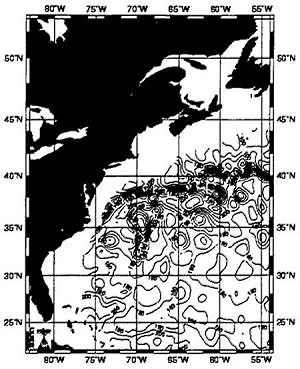
TOPEX/ERS-2 Analysis Nov 2 2000
Fig.1 Distribution of sea surface dynamic height (SSDH) of Gulf Stream area derived from the T/P and ERS-2 altimeter data on November 2,2000.(from CCAR's WWW)
SSDH was determined as anomaly(cm)from a temporary mean geoid surface,
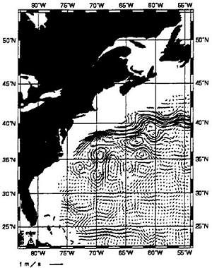
TOPEX/ERS-2 Analysis Nov 2 2000
Fig, 2 Water movement patterns of Gulf Stream area estimated based on SSDH derived from the T/P and ERS-2 altimeter data on November 2,2000. (from CCAR's WWW)
Arrow indicates velocity equivalent to I m/sec.