M. Matsuyama et al./Continental Shelf Research 19 (1999) 1561-1575
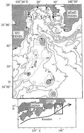
Fig. 1 (Upper panel) Bottom topography in Sagami Bay and locations of the observation stations. Bottom contours are in meters. KO is location of fishing set-net. Stations EN, HI, KA, and JG are locations of current and/or temperature measurements. Stations ME, AB, IT, OK, KZ, and MK are locations of tidal stations. Stns. 1-5 are locations of CTD casts on January 6,1994. (Lower Panel) Schematic view of the Kuroshio path south of Japan.
The Kuroshio flows eastward south of the Japan Coast and its path is well known to be variable south of Sagami Bay (e. g. , Kawabe, 1985). The warm water originating from the Kuroshio, which is 2-3℃ warmer than the bay water, is well known to suddenly intrude with high velocity near the bay coast at times. This phenomenon, named the Kyucho (stormy current), has destroyed fishing set-nets at the coast and has caused much damage to the fisheries (Kimura, 1942; Uda, 1953; Matsuyama and Iwata, 1977; Matsuyama et al. , 1997). During the Kyucho in April 1975, the warm water front moved with the speed of about 1 ms-1 along the coast cyclonically, as shown by the temperature records observed at three stations (Matsuyarna and Iwata, 1977).