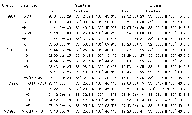
Table 1. Observation periods, positions of the observation lines and observation items. These lines are taken roughly parallel to the coastline.In the names of lines and of runs, the first Roman numbers indicate the cruise number; the capitals A through E indicate the observation lines parallel to the coast line in alphabetic order from coast to offshore in each cruise: small letters a through c indicate the north-south observation lines in Cruise I from west to east. The A Iines were taken roughly along the 100 m depth contour, and identical for all cruises (the standard line).The CTD used was the Niel-Brown Mark 111B, and the ADCP was the CI-30 of Furuno Electric Co. Current speeds at three prescribed levels can be measured, and 5 m, 25 m and 50 m levels were selected in Cruise I, 5 m, 25 m and 75 m levels in Cruises II and III, and 5 m, 25 m and 65 m levels in Cruise IV, respectively. The observation periods of the repeated runs are shown on the right in the corresponding figures.
2. Observations
The R/V Seisui-maru of the Mie University was sent to the area in the vicinity of Cape Shionomisaki, the tip of the Kii Peninsula, four times: October 29-31, 1996 (Cruise I), June 24-26, 1997 (Cruise II), October 14-16, 1997 (Cruise III), and December 3-4, 1997 (Cruise IV).The repeated ADCP observations were conducted along the standard line in each cruise, and multiple-line ADCP observations were conducted in Cruise II and III. Additional STD and XBT observations were made in Cruise I and II. The observation items of each observation run of each cruise are given in Table 1, with their identification name.
The temporal variation of the daily average value of the sea level difference between Kushimoto and Uragami is shown in Fig. 2 for the period from October 1996 to December 1997. The sea level difference is calculated simply from the raw values reported by the Japan Meteorological Agency, as was reported in Fujita (1997).
The observation periods are indicated by thick bars at the bottom of the figure. The horizontal dashed line at 25 cm difference is the threshold value, indicating whether the Kuroshio is taking the straight path or the large meander path: the straight path usually occurs if the difference is larger than 25 cm, and the large meander path if it is close to or a little smaller than 25 cm. Fujita (1997) and Sekine and Fujita (1999) obtained this threshold value by investigating the relation between the bimonthly average sea level difference and the position of the Kuroshio axis measured from the tip of the Kii Peninsula for the period from 1975 to 1994. The position of the axis was determined by using the Prompt Report of the Oceanographic Condition published bimonthly by the Hydrographic Department, Maritime Safety Agency of Japan. This threshold value might not be directly applicable for the temporal variations having time-scales shorter than a half month, but we shall use this as a measure of the axis position or of the oceanic structure in the coastal side of the Kuroshio current zone in the area under consideration.
On Structure and Temporal Variation of the Bifurcation Current off the Kii Peninsula