Ocean acoustic tomography is a powerful method for estimating large-scale ocean temperature and current structures by measuring acoustic travel times along various acoustic ray paths through the volume and reconstructing the distribution of oceanic parameters (sound speed, very nearly temperature, and current velocity) affecting travel times by using inverse methods [Munk and Wunsch, 1979; Munk et al., 1995]. Large-scale three-dimensional ocean acoustic tomography experiments were performed with ranges less than 600-km in the Mediterranean [Send et al., 1997], in the Greenland Sea (200-km domain) [Morawitz et al., 1997], in the northern partion (200-km domain) of the Gulf Stream southern recirculation gyre [Chester et al., 1994], and the large-area (1000-km domain) high-resolution mapping by moving ship tomography in the northwestern Atlantic [AMODE-MST group, 1994]. Until now, no attempts to perform multi-station ocean acoustic tomography experiments have been done in the northwestern Pacific, though the 1991-1992 El Nino was successfully detected by a single slice experiment conducted in the Philippine Sea [Yuan et al., 1995, Kaneko et al., 1996].
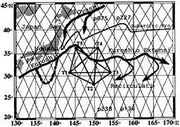
The Kuroshio Extension region is a good demonstration site for a multi-station experiment because depths exceed 5000 m permitting horizontal coverage over basin scales as well as acoustic rays that sample the ocean water column from the surface to the deep interior. These conditions provide ideal conditions for conducting our frrst 1000-km scale four-dimensional ocean acoustic tomography experiment in the Kuroshio Extension region. The objectives of the experiment are to (1) demonstrate the capability of the tomographic techniques in monitoring the variability of the 1000km-scale three-dimensional oceanic structures (both the temperature and current fields) in the Kuroshio Extension region, (2) confirm the reliability of transceiver moorings in preparation for the next two long-term, 1000-km scale tomography experiments, in (a) the Central Equatorial Pacific Tomography Experiment (CEPTE) from December 1998 to December 2000, and (b) the Kuroshio Extension Study experiment (KES) in the Kuroshio Extension region from 2001 to 2005.
In this paper, we report the preliminary results of the 1000km-scale, four-dimensional experiment that has been conducted in the Kuroshio Extension region from July to September 1997.